The text-based, obscure system created in the time of telegrams & teletype that hinders the full implementation of the Future Air Navigation System.
By Dejan Damjanović & David Bjellos
Notices to air missions (NOTAMs) remain a paradox for airmen. Cryptic, cumbersome and confusing, they retain the basic format originally conceived during World War II. The topic has had a very public run in recent years, and with continued efforts by FAA, ICAO, and industry, the solutions are taking shape.
An FAA program called System Wide Information Management (SWIM) will make data-sharing possible to support NextGen goals of real-time information (especially enhanced NOTAMs) to users through Aeronautical Information Management (AIM).
SWIM is being implemented in phases, and NOTAMs will be addressed once the peer-to-peer architecture is finalized. Currently the National Airspace System (NAS) is only capable of processing data at the application (individual) level. In other words, no large scale, realtime data-sharing yet.

Four components of a NOTAM. Early NOTAMs were published in forms of magazines by the UK, USA, and other countries, as a supplement to their Annex-15 Aeronautical Information Publication (AIP).
How did all this get started?
The acronym NOTAM was synonymous with the establishment of the Convention on International Civil Aviation (CICA) in 1947 – often referred to as the ICAO Convention. These were inspired by similar paper publications in the Maritime world called “Notices to Mariners” that warned of known hazards to shipping.
It soon became necessary to better coordinate the publication dates of NOTAMs and Aeronautical Information Publications (AIPs), so that any flight operation could ensure that they used the most current information from departure to destination. In 1964, ICAO solved the synchronization challenge establishing the the aeronautical information regulation and control (AIRAC) cycle. Information could be published every 56 days or 28 days, so that as long as each ICAO country complied, the flightcrew could assemble all applicable AIP changes from the latest AIRAC publication date and the most current NOTAMs, and proceed with their flights.
Aeronautical charts were (somewhat) similarly published on the same cycle, ensuring the success of domestic, regional, and transcontinental aviation just as the jet age began. However this gave rise to a unique scenario where charts and AIPs were not always in sync, which raised that frequent ugly question to flightcrews – Which one is correct?
As NOTAMs proliferated, ICAO, in parallel, addressed the requirements to distribute them reliably, leading to the formation of the dedicated Aeronautical Fixed Telecommunications Network (AFTN) in the early 50s. This increased situational awareness greatly, as flightcrews could rely on information about issues at airports and airspace that affected their missions before departing.
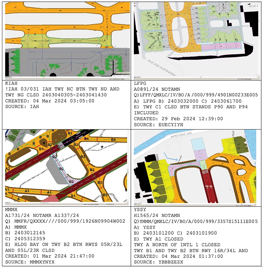
Examples of D-NOTAMs. As illustrated, the closure of a taxiway is represented by changes in color of that taxiway. Similarly, the shortening of a runway is represented by segmenting that runway into usable and non-usable portions on the image of the airport. For busy flightcrews inbound to an airport in hard IFR, or early morning foggy departures from complicated airports, the improvement in situational awareness is immense and represents a quantitative leap forward in runway incursion protection.
The urge to provide flightcrews with more and more information was inexhaustible – SNOWTAMs were introduced in 1968 to advise of snow, ice, and surface contamination. In the 1980s ASHTAMs were introduced to warn of volcano activities, eruptions and subsequent ash cloud formulations and propagation into navigable airspace. ICAO grew from 52 signatories in 1952 to 193 member states of today (as of 2019), representing many thousands of airports that all required reliable dissemination of AIM.
Unsurprisingly many countries incorporate subtle differences in how they chose to implement/apply NOTAMs, so individuals had to become experts at interpreting such cryptic messages to achieve a complete picture of every facility along an intended route of flight. Retention of this flood of data was further compromised by the addition of supplements and amendments, adding to the frustration and workload of airmen during the planning phase.
The industry started developing rudimentary computers to manage our commercial flight operations (eg, Honeywell FMS for the 757/767 in 1978), that lead to the development of ARINC-424 (the industry’s standardized database format for all FMS/FMC digital communications). The proliferation of this automation has further enabled the rapid rise in all-weather predictable flight operations. But it also broadened and deepened the dilemma with NOTAMs that only could be obtained through an ARINC-424 database. As eastern aircraft (eg, Russia, eastern bloc and China) adopted and installed ARINC-424 equipment and protocols in the 1990s, the negative effects were greatly diminished.
This initiative has indeed resulted in much greater consistency in the AIM communicated, but the sheer numbers have continued to grow exponentially, and most critically obsolete NOTAMs have been left far too long to proliferate. To quote ICAO’s own statistics, “On any given day, there are some 35,000 active NOTAMs circulating in the global air transport system. In 2020, the total number of NOTAMs issued exceeded 1.7 million.” This served as the catalyst for ICAO to launch in 2021 the global campaign on NOTAM improvement (NOTAM–2021). The intention is the two-fold elimination of excessive and obsolete NOTAMs and further adherence to the established standards promulgated by ICAO.
Beginning in the US NAS, the FAA system will be known as SWIM flight data publication service (SFDPS). It is expected that ICAO and EASA will adopt all of the proposed protocols for European/global flight operations. It will enable flight planners, dispatchers, and airmen access to real-time tools for planning, execution and completion of an individual flight (with built-in contingencies for single/multiple diverts along the planned route).
Flight-specific data would be customized for the aircraft, route, available alternates and destination. And it will be updated inflight through Wi-Fi, CPDLC or other datacomm sources. Testing and implementation of this enterprise-level architecture is under way, and SFDPS has been in the testing phase since late 2017 at the Salt Lake City UT and Atlanta GA network enterprise management centers.
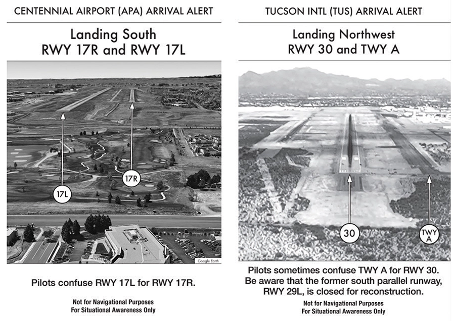
Examples of FAA Advance Arrival Notice (AAN).
Digital and graphical NOTAMs
Since its inception, the inherent weakness of a NOTAM is the difficulty of visualizing the cryptic text and applying it dynamically into the geospatial 4-D world in which we fly, so it was up to flightcrews to perform the mental gymnastics of assimilation and integrating that during the planning and/or execution phases of flight.
We already use digital models of airports in surface radar applications (ASDE-X), and many pilots have similar ones (known as Airport Mapping Database [AMDB]) in their portable electronic flight bags or more advanced installed avionics, such as Honeywell’s Block 3 in Gulfstream G650 aircraft). Integrating D-NOTAMs and continued application of innovative graphics will only enhance our situational awareness (SA) and increase safety of flight.
The ultimate goal: improving SA
Electronic flight bag (EFB) providers are increasingly displaying airport mapping databases on those tablets, and some are experimenting with displaying D-NOTAMs when such information is made available by the local civil aviation authority (CAA) or air navigation service provider (ANSP).
In a bid to improve today’s significant risks of runway incursions, FAA has implemented a novel program to aid pilot SA at major airports (41 as of this 2024 writing) known as Arrival Awareness Notices (AANs). This is a series of still graphics showcasing specific conditions at airports due to issues normally reported by textual NOTAMs, but better illustrated with a graphic that is usually taken on the approach or departure to the runway(s) in question.
This is an excellent first step using a manual process to create these AANs, but until we have digital airport databases for all of the 3400 eligible airports of the US NAS, these cannot be created automatically at the issuance of every NOTAM for which there would be such an important airport change.

Summary
As information changes in real time, changes can be accessed by the pilot enroute either through an automatic uplink message from dispatch or service provider, or a manual FMS update request (think wind, weather, ATIS). This is exactly why SWIM was conceived and created. Satellite and ground-based Internet/datacomm services are making this option increasingly affordable.
How do we ensure the security of all this digital data flying around in real time? A critical enabling technology piece for flightcrew, aircraft, and ATM authorities is called Blockchain. (See https://www.icao.int/about-icao/partnerships/Pages/Blockchain-Sandbox.aspx).
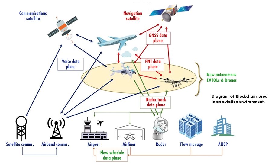
In its simplest form, Blockchain is a public form of digital identity and repository toward which the aviation community will be increasingly moving (think 2-factor authentication), to prevent the kind of unauthorized ATM piracy that’s now permeating over the Horn of Africa airspace (and boundless to spread). At present, controller pilot data link communications (CPDLC) operates in a protected mode both domestic and internationally. But it’s still vulnerable, just as GPS spoofing has shown in the past year. Blockchain will be as much or more about security as information in our increasingly digital cockpits.
Each ICAO signatory nation who complies with the PANS-AIM successor to the legacy Annex-15 (Aeronautical Information Management or AIM), will either perform this AIM transmission themselves, or most likely delegate some/all aspects of this to responsible, approved third parties such as their ANSPs, dispatch centers, and other affected and authenticated stakeholders, such as L3Harris, Honeywell, Thales, or Jeppesen.
This is coming soon, because the Future Air Navigation Systems (FANS) promise of NextGEN and SESAR cannot be realized without the elimination of this increasingly inflexible, inefficient triple-headed combination of AIRAC, AIC, and NOTAMS.
Establishing a single authoritative entity that provides aeronautical information – extracted from each country’s PANS-AIM Aeronautical Data Catalog – in real time for planning/execution of all flight operations is not only the goal, but also mandatory for continued safe and digitally secure flight operations.
 Dejan Damjanović is the project manager for Aviation Geospatial Solutions with Woolpert, a Ohio-based global firm. Damjanović is a senior enterprise architect who has worked with Jeppesen and other world-class geospatial service providers.
 Senior contributor David Bjellos has been writing for PP since 2004. He is an active airman flying a G650 based in south Florida.